
Building Height
The zoning ordinance regulates height of structures in all zones. The maximum height varies by zone and Certified Site Plan.
Building height is determined from the Average Front Grade of a structure. Sea level elevations along the front wall are required to determine what that average is. In the R-40, R-60, R-90 and R-200 zones (if the lot area is less than 40,000 sq. ft.), the following information is required and MUST be prepared (drawings signed and sealed) by a Md. licensed land surveyor, civil engineer or architect.
Check with Find Your Zone and then check your height under SETBACKS on the Zoning Division page.
How to Measure
59.4.1.7.C. Height
Building Height in Agricultural, Rural Residential, and Residential Zones
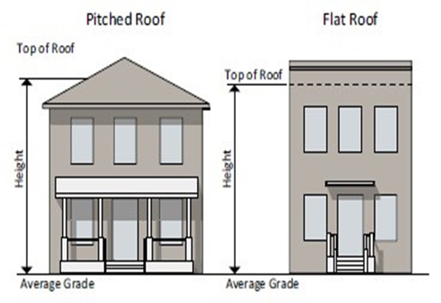
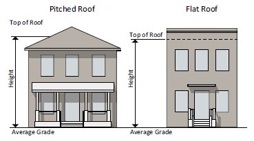
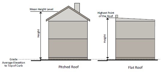
- Building height is measured from the average grade either to the mean height level between the eaves and ridge of a gable, hip, mansard, or gambrel roof or to the highest point of roof surface, regardless of roof type.
- Average grade is calculated using the weighted average of point grades for each wall length along pre-development or finished level of ground (whichever is more restrictive), along the front of the building parallel to the front setback line. The weighted average of point grades for each wall length is calculated by multiplying each front facing wall section times the grade elevation adjacent to that section, summing all products, and dividing by the total length of the front wall.
Building Height in Commercial/Residential, Employment, and Industrial Zones
- For a building located within 35 feet of a street right-of- way, building height is measured from the level of approved curb grade opposite the middle of the front of a building to the highest point of roof surface of a flat roof or to the mean height level between eaves and ridge of a pitched roof. If a building is located on a terrace, the height may be increased by the height of the terrace. For a corner lot or a lot extending through from street to street, the height is measured from the curb grade opposite the middle of the building façade along either right-of- way; however, under Section 7.3.4, Site Plan, the Planning Board may approve an alternative point of measurement as part of site plan approval. The alternative measurement point must be taken from the approved curb grade along either right- of-way. In approving an alternative point of measurement, the Planning Board must consider compatibility and building height variation on the site.
- If a building is set back from the street line 35 feet or more, then the building height is measured from the average elevation of finished ground surface along the front of the building.
Height Encroachments
Any height encroachment not specifically listed is prohibited.
- The following roof structures may occupy a maximum of 25% of the roof area: a spire, belfry, cupola, dome not intended for human occupancy, chimney, flue or vent stack, flagpole, monument, water tank, television antenna or aerial, air conditioning unit, or similar structure or mechanical appurtenance (not including a rooftop renewable energy system). A larger area may be approved by the Planning Board under optional method development in the Commercial/Residential and Employment zones.
- The maximum height does not apply to solar panels and any roof structure listed in Section 4.1.7.C.3.a, except that in the TLD, TMD, THD, and R-30 zones, an air conditioning unit or similar structure or mechanical appurtenance may exceed the established height limit by a maximum of 8 feet.
- In the CRT, CR, Employment, and Industrial zones, the following may exceed the established height limit by up to 8 feet, except when located within an airport approach area:
- rooftop deck, patio, shade structure;
- rooftop garden, landscaping;
- parapet wall;
- rooftop rainwater collection or harvesting system; and
- rooftop renewable energy system, such as a solar panel or wind turbine.
- An accessory structure located on the roof must not be used for any purpose other than a use incidental to the principal use of the building.
- A public building may be a maximum of 120 feet; but the minimum front, rear, and side setbacks must be increased 1 foot for each foot above the maximum height allowed in the zone.
Height in Airport Approach Areas
The height of any building or structure, including any structure regulated under Section 4.1.7.C.3, must be limited to provide a clear glide path from the end of the usable landing strip. The glide path is a plane surface laid out according to the operating characteristics of the aircraft for which the airport is designed, and under the criteria in the airport's conditional use approval.
The first 500 feet of such glide path must be wholly within the airport.