


RESOURCES
Walkability Studies
MCDOT performs walking area analyses of 15 to 20 schools within the Montgomery County Public School (MCPS) District each fiscal year. These evaluations include observation of arrival and dismissal operations of the school, coordination with school staff and crossing guards, as well as a comprehensive inventory and condition assessment of street networks for pedestrian safety and walkability throughout each school walkshed. The walkability studies summarize observations related to existing conditions, identify safety hazards, infrastructure deficiencies, and provide recommendations for improving the safety of those walking and rolling to and from school. Recommendations range from minor signing and pavement marking improvements to the construction of intersection improvements and adding new sidewalk where there is missing sidewalk in the network to provide safe and accessible pathways for all students.
The interactive map below identifies the status of walkability studies for each MCPS school. To download the study for a particular school with "complete" status, please zoom and navigate to the school location and select the point representing the school.
Ongoing Walkability studies
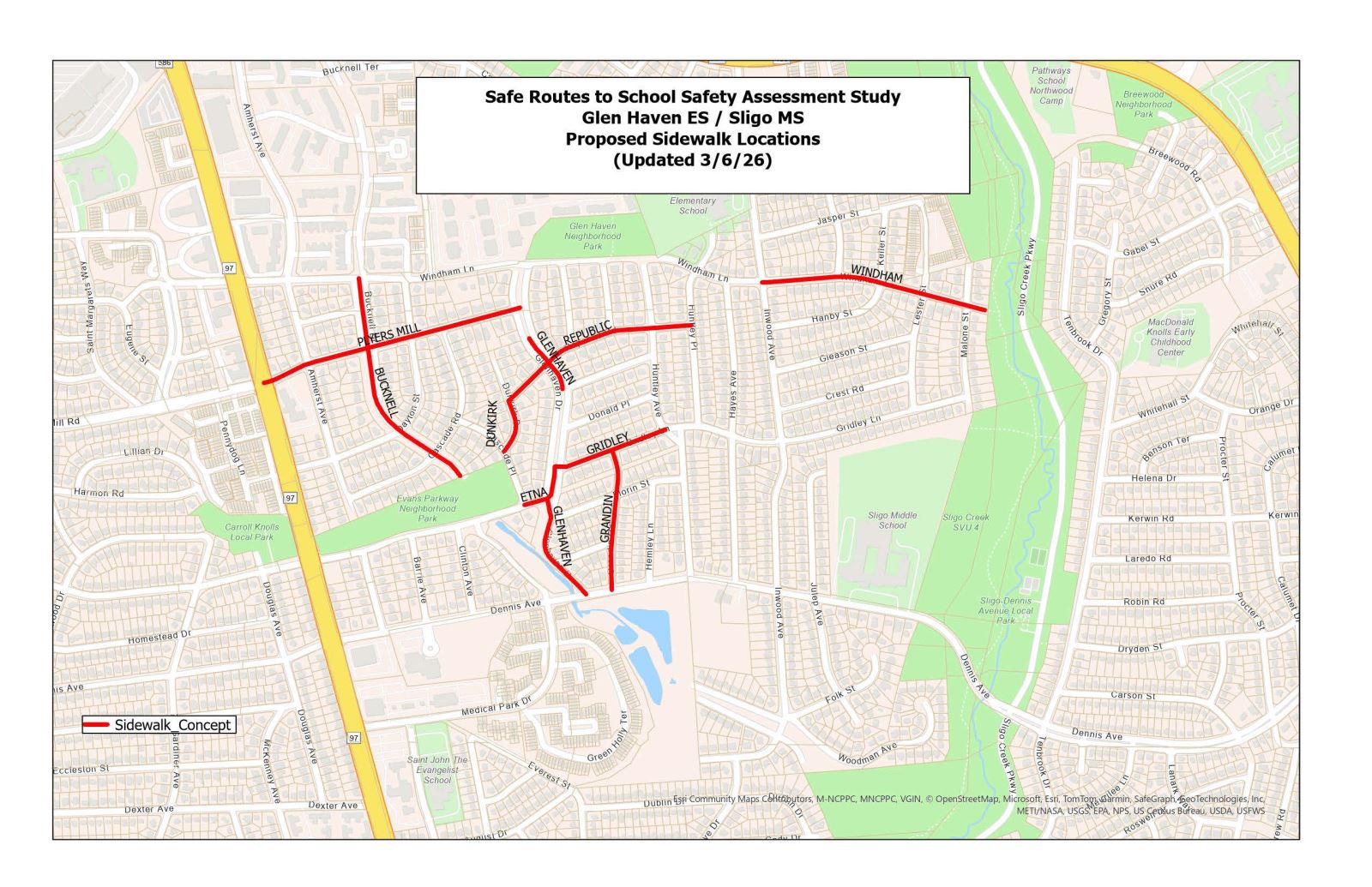
Glen Haven Elementary School / Sligo Middle School
Martin Luther King MS, Lake Seneca ES, and Waters Landing ES
Sidewalk Gap Build Out
Each school walkshed is reviewed for sidewalk connectivity and accessibility as part of the safety evaluation process. Key walking routes are prioritized to ensure students walking to school are provided with dedicated space outside of vehicular travel ways along a street segment. Based on feedback received from school officials, observations of travel patterns, road user behaviors, and the layout of the street network relative to the school attendance boundaries, critical gaps in the sidewalk network are identified. Locations where critical sidewalk gaps are identified go through a constructability review to determine potential site constraints such as property lines, drainage patterns, impacts to street trees, and other considerations. Once locations where critical sidewalk gaps have been identified are determined to be constructable, implementation is prioritized as funding becomes available.Pending SRTS sidewalk implementations are listed below.
Martin Luther King MS
- Wanegarden Drive – Between Lake Seneca Elementary School and Wynnfield Drive
- Waldorf Drive – East side, between Wisteria Drive and Wynnfield Drive
- Teakwood Lane – Between the Willow Cove Manor driveway entrances, connecting to the existing sidewalk network on both ends
MCDOT will also proceed with crosswalk modifications at the following locations:
- Wanegarden Drive
- Waldorf Drive
- Wisteria Drive
- Teakwood Lane
Glen Haven ES and Sligo MS Walkshed
Travilah Elementary School
Approximately 0.3 miles (1600 linear feet) of five-foot-wide concrete sidewalk is being constructed from Travilah Road to Quince Orchard Road. Pedestrian ramps and a crosswalk will be added across Dufief Mill Road at Quince Orchard Road. Link to view the Plan
Cabin John Middle School
Approximately 0.45 miles (2400 linear feet) of five-foot-wide concrete sidewalk is being constructed along Bells Mill Road, from Gainsborough Road to Fox Hills Trail. Existing ramps will be rebuilt to be ADA-compliant, and high-visibility crosswalks will be installed. Link to view the Plan
Roscoe Nix ES
Approximately 0.22 mile (1160 linear feet) of five-foot-wide concrete sidewalk will be constructed along Mount Pisgah Road from Oakview Drive to Grey Castle Way. Link to view the Plan
Northwood High School
Approximately 0.13 miles (700 linear feet) of five-foot-wide concrete sidewalk is being constructed along Gabel Street from Breewood Road to University Blvd. Link to view the Plan
Safety Spot Improvements
The SRTS program also pursues safety improvements based on recommendations from Complete walkability studies and requests from County residents. Safety recommendations that can be Complete through maintenance efforts and minor construction within public rights of way are implemented as funding and resources become available. Equity Emphasis Areas (EEA), Bicycle and Pedestrian Priority Areas (BiPPA), Pedestrian Level of Comfort (PLOC),and cost-benefit analyses are all considered when prioritizing SRTS safety improvements.While the SRTS program is a proactive safety initiative, MCDOT is responsible for maintaining or enhancing the safety of roadways throughout the County and often receives requests for safety improvements from residents, civic organizations or public officials. When safety issues are verified by MCDOT staff, mitigation of the hazard(s) is recommended, and adjacent, impacted properties are notified.
Pending and Complete SRTS spot safety improvements are listed below.
Oakland Terrace Elementary School
Gardiner Avenue / Dennis Avenue
This intersection will be converted to an all‑way stop with crosswalks on all approaches. Existing flex posts will be replaced with concrete bump‑outs.
Concept plan _ Gardiner Avenue / Dennis Avenue
Brunswick Avenue / Plyers Mill Road
This intersection will also be converted to an all‑way stop due to its proximity to Oakland Terrace Elementary School and high pedestrian activity. Curb bump‑outs will be added at all corners to improve visibility, reduce crossing distances, and calm traffic.
Concept plan _ Brunswick Avenue / Plyers Mill Road
Fairland Elementary School
Fairdale Road
Construction of a permanent bump‑out to prevent parking in the no‑parking zone in front of the school, plus a new crosswalk before the car‑loop entrance and upgraded signage to improve pedestrian visibility.
Concept plan _ Fairdale Road
Roberto Clemente Middle School
A new crosswalk will be installed at 6700 Sioux Lane to connect the off‑street trail to Ridgeview Middle School.
Concept plan _ Sioux Lane
Beverly Farms Elementary School
This intersection will be converted to an all‑way stop, with high‑visibility crosswalks and concrete curb bump‑outs added on all three approaches to shorten crossing distances and improve pedestrian safety.
Concept plan _ Postoak Road & Milbern Drive
Clarksburg High School
Construct pedestrian safety improvements at the Ivy Leaf Drive/ Diller Lane and W Old Baltimore Road intersection. The improvements include a new crosswalk and pedestrian refuge island to allow pedestrians to safely cross W Old Baltimore Road.
Draft concept plan- Ivy Leaf Drive/ Diller Lane and W Old Baltimore
Montgomery Blair High School, Pedestrian Safety Improvements -Lexington Drive at Pierce Drive- Status: Complete, Fall 2023
Proposed safety improvements at the intersection of Lexington Drive and Pierce Drive includes the construction of 200 linear feet of concrete sidewalk to connect the intersection to the existing signalized pedestrian crossings at University Parkway East (MD 193) at Lexington Drive, as well as a curb extension, pedestrian ramps, and high visibility crosswalk.
Lexington Drive Concept Plan
Sligo Creek Elementary School, Pedestrian Safety Improvements –Schuyler Road at Greenwich Lane- Status: Complete, Fall 2023
Pedestrian safety, accessibility, and traffic calming improvements along the elementary school frontage include the upgrade of pedestrian ramps to meet ADA guidelines, removal of the midblock crosswalk markings, conversion of Schuyler Rd at Greenwich Ln to an all-way stop controlled intersection, high visibility crosswalks, and tightening of the geometry at the intersection to promote slower turning movements and shorten crosswalk lengths.
Sligo Creek ES Improvement Plan
Herbert Hoover Middle School, Pedestrian Safety Improvements – Tuckerman Lane (From Duryea Drive to Postoak Drive)- Status: Complete, Summer 2024
Proposed safety improvements along Tuckerman Lane from Postoak Road to Duryea Drive include the installation of approximately 500 linear feet of sidewalk along the southern side of Tuckerman Lane. This new sidewalk will provide a pedestrian path leading to the Postoak Road intersection, where a school crossing guard is present for arrival and dismissal. Additionally, a pedestrian refuge island and a crosswalk will be added at Tuckerman Lane and Postoak Road intersections and existing ramps will be rebuilt to be ADA-compliant.
Tuckerman – Herbert Hoover Concept Plan
Earl B Wood Middle School, Bauer Drive and Burnside Drive Intersection Improvements- Status: Complete, Summer 2024
Pedestrian safety, accessibility, and traffic calming improvements at the middle school entrance includes upgrade of pedestrian ramps to meet ADA guidelines, pedestrian refuge island, high visibility crosswalks, and tightening of the geometry at the intersection to promote slower turning movements and shorten crosswalk lengths.
Bauer and Burnside Intersection Improvement Concept Plan
Sally K. Ride Elementary School, Status: Complete, Summer 2024
Pedestrian safety and accessibility improvements at two intersections along Seneca Crossing Drive and they are: Seneca Crossing Drive at Settlers Circle and Seneca Crossing Drive at Virginia Pine Terrace/Seneca Forest Circle. The improvements include upgrading the pedestrian ramps to meet ADA guidelines and new high visibility crosswalks.
Sally K. Ride ES Improvement Plan
Jackson Road Elementary School: Status: Complete, Fall 2024
Pedestrian safety, accessibility, and traffic calming improvements along the elementary school frontage includes the conversion of Jackson Road and Renick Road to an all-way stop-controlled intersection with a new pedestrian ramp and a high-visibility crosswalk. Additionally, pedestrian refuge island, high-visibility crosswalks, and tightening of the geometry at the intersection of Jackson and Arbie Road will promote slower turning movements and shorten crosswalk lengths. Concept Plan(Link to the attached Jackson Road Concept)
Jackson Road ES Concept plan
Cold Spring Elementary School: Status Complete, Fall 2024
Construct pedestrian safety improvements at the Lamp Post Lane and Falls Chapel Way intersection. The improvements include a new crosswalk and pedestrian refuge island to allow pedestrians to safely cross Falls Chapel Way and access the existing sidewalk leading to Cold Spring Elementary School.
Cold Spring ES Concept Plan
Captain James E. Daly Elementary School: Status Complete, Fall 2024
Pedestrian safety, accessibility and traffic calming improvements at the elementary school entrance include a high-visibility crosswalk and a pedestrian refuge island at the intersection of Brandermill Rd. and Bloomingville Ct.
Capt James Daly ES Concept Plan
Counselman Road: Status Complete, Fall 2024
Pedestrian safety, accessibility and traffic calming improvements along Counselman Road include the conversion of Glenolden Drive and Counselman Road to an all-way stop controlled intersection. We will also install approximately 350 linear feet of sidewalk along Counselman Road leading to St. Andrews Episcopal School.
Counselman Road Concept Plan
Judith Resnik Elementary School, Status: Complete, Summer 2024
Pedestrian safety and traffic calming improvements along Hardley Farm drive include median extension and flex posts to slow motorists when making the right turn and slightly shorten the pedestrian crossing distance.
Dr Judith Resnik ES Concept Plan
Woodlin Elementary School: Status Complete, Fall 2024
Pedestrian Safety improvements at Woodlin Elementary School include installation of ramps and Circular Flashing Beacon at Montgomery St. and Brookville Road. These improvements will provide safe crossing space for students and parents walking and biking to school.
Woodlin CFB Plan
North Bethesda Middle School
Proposed safety improvements along Bradmoor Drive include 600 linear feet of sidewalk and intersection improvement at Bradmoor Drive/Rolston Road and Lindale Drive. MCDOT has developed three design alternatives, and they are:
- The first alternative includes sidewalks along the median, a new roundabout, and crosswalks at Rolston Road, Bradmoor Drive, and Lindale Drive intersections
- The second alternative includes sidewalks along the median, an all-way stop, and crosswalks at Rolston Road/Bradmoor Drive and Lindale Drive intersection
- The third alternative includes a 6’ sidewalk along the southern side of Bradmoor Drive (even number home)
Sligo Creek Elementary School, Pedestrian Safety Improvements
The MCDOT Safe Routes to Schools (SRTS) Program has proposed a pedestrian facility along Windsor Street; this proposed facility will begin at Dartmouth Ave. and connect to the existing sidewalk on Schuyler Road. The proposed pedestrian facility will provide safe access for students traveling to and from Sligo Creek Elementary School. MCDOT has prepared three design alternatives for pedestrian facilities along Windsor Street and is requesting feedback from the community on these alternatives. Concept plans illustrating these three alternatives can be viewed at this link.
Windsor Street Pedestrian Improvements Plan
Carderock Springs Elementary School, Pedestrian Safety Improvements
Permission Tree Road and Tomlinson Avenue
Proposed safety improvements include the installation of a new crosswalk and Americans with Disabilities Act (ADA)-accessible ramps at Tomlinson Avenue. The crosswalk will provide safe access to the sidewalk leading to Carderock Spring Elementary School.
Permission Tree Road and Tomlinson Avenue concept plan
Wyngate Elementary School, Pedestrian Safety Improvements
Kirkdale Road and Wilmett Road
Proposed safety improvements include the installation of a new crosswalk and Americans with Disabilities Act (ADA)-accessible ramps at Kirkdale Road and Wilmett Road. The crosswalk will provide safe access to the sidewalk leading to Wyngate Elementary School.
Kirkdale Road and Wilmett Road concept plan
Ridgeview Middle School, Pedestrian Safety Improvements
Longdraft Road and Frenshire Road; Longdraft Road and Sioux Lane
Proposed safety improvements include a new crosswalk and pedestrian refuge island at Longdraft Road and Frenshire Road and a miniature concrete barrier at Longdraft Road and Sioux Lane. The proposed barrier will prevent drivers from using the existing shoulder area to bypass the queue of vehicles waiting at the intersection. Additional concrete barriers proposed at the northeast and northwest corners of the intersection will slow down the drivers while making right and left turns from Sioux Lane to Longdraft Road. Longdraft Road and Frenshire Road;
Longdraft Road and Sioux Lane concept plan
Sligo Middle School, Pedestrian Safety Improvements
Tenbrook Dr. and Rosewell Drive; Dennis and Julep
Proposed safety improvements include a new crosswalk and pedestrian refuge island at Rosewell Drive /Tenbrook Drive and Dennis/ Julep Avenue.
Sligo Middle school Safety improvements concept plan.
East Silver Spring Elementary School
Sligo Avenue and Carroll Lane/Mississippi Avenue
Proposed safety improvements include concrete bump outs at the intersection of Sligo Avenue at Carroll Lane/Mississippi Avenue to improve sight lines. Signs will be added, and we will upgrade the existing crosswalk markings.
Sligo Avenue and Carroll Lane/Mississippi Avenue concept plan
Woodlin Elementary School
Brookville Road Sidewalk
The proposed safety improvement include addition of approximately 600 linear feet of sidewalk along the westbound side of Brookville Road, extending from Warren Street to Montgomery Street.
Brookville Road Sidewalk Plan
Louis Street and Lanier Drive/Luzerne Avenue
The intersection will be narrowed by installing bump-outs at existing corners of Louis Street. Louis Street will be realigned to meet Luzerne Avenue/Lanier Drive at a right angle. The proposed geometric improvements will force drivers to slow down before turning at the intersection.
Luzerne and 2nd
All pedestrian ramps at the intersection will be upgraded to meet ADA standards, and the crosswalks and stop lines will be refreshed.
Luzerne and Glenridge: Existing pedestrian ramps will be upgraded to meet ADA standards. A new pedestrian ramp will be installed along Luzerne Avenue for a new crosswalk across Luzerne Avenue at this existing all-way stop intersection. Existing crosswalks and stop lines will be refreshed.
Luzerne and Warren Streets
A new crosswalk with pedestrian warning signs will be installed for a new marked crossing across Luzerne Avenue. Existing pedestrian ramps will be upgraded to meet ADA standards. The existing ramp at Georgetown Branch Trail will be removed so that pedestrians cross at the new crosswalk location.
Safety Improvements concept plan
Viers Mill Elementary School
Proposed safety improvements include speed humps along Garrett Park Road. To learn about speed humps and view the plan, please visit: https://www.montgomerycountymd.gov/DOT-Traffic/SpeedHumps/GarrettParkRd.html
Roberto Clemente Middle School
Waring Station Road and Summer Oak Drive/School Entrance
Proposed safety improvements include installation of pedestrian bump outs on all four corners of the intersection of Waring Station Road and Summer Oak Drive/School Entrance in order to shorten pedestrian crossing distances at the intersection. Additionally a pedestrian refuge island will be installed in the existing two way left turn lane for the north leg crossing across Waring Station Road. The southbound Waring Station Road shoulder will be restriped as a right turn lane for right turns into the school entrance. Bump outs will also be installed at the bus/staff school entrance just south of the intersection at Summer Oak Drive to reduce vehicle turning speeds. All pedestrian crosswalks will be restriped as high visibility crosswalks.
Waring Station Road and Summer Oak Drive/School Entrance concept plan
Wood Acres Elementary School
Montgomery County Department of Transportation’s (MCDOT) has scheduled the construction of Safe Routes to School (SRTS) safety improvements at four intersections within the Wood Acres Elementary School walkshed. This project is part of our ongoing efforts to enhance pedestrian safety, accessibility, and overall community infrastructure.
The planned construction includes:
- The installation of concrete refuge islands and curb extensions at the following intersections:
• Springfield Drive and Ridgefield Road
• Cromwell Drive and Knollwood Road
• Cromwell Drive and Marengo Road - The installation of a concrete roundabout at Cromwell Drive and Brookeway Drive
Watkins Mill High School, Pedestrian Safety Improvements
Watkins Mill Road from Apple Ridge Road to Greenway Trail
Proposed safety improvements along Watkins Mill Road include installation of approximately 1,350 linear feet of sidewalk on the northern side of Watkins Mills Road from Apple Ridge Road to the Greenway Trail.
Watkins Mill High School sidewalk concept plan
Sargent Shriver Elementary School
Bushey Drive and Elby Street
Proposed safety improvements include the installation of bump-outs at all four corners of the intersection. These improvements will help open sight lines at the approaches, shorten pedestrian crossing distances, physically deter illegal parking, and promote traffic calming by narrowing the travel lanes.
Bushey Drive and Elby Street Concept Plan
......